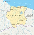
suriname political map with capital paramaribo most important cities national borders |
||||||||||||||||||||||||||||||||||||||||
| navigate by keyword : totness suriname lelydorp guyana guiana brokopondo blommestein bitagron apoera albina geography america americas country republic atlantic atlas coastline caribbean reservoir cartography french climate brazil ocean tropical travel paramaribo political map |
||||||||||||||||||||||||||||||||||||||||
|
||||||||||||||||||||||||||||||||||||||||
| Suriname Political Map featuring the capital Paramaribo, key cities, and clearly marked national border |
||||||||||||||||||||||||||||||||||||||||
|
Stockphotos.ro (c) 2025. All stock photos are provided by Dreamstime and are copyrighted by their respective owners. |
||||||||||||||||||||||||||||||||||||||||