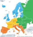
europe subregions geoscheme for statistical purposes political map

navigate by keyword : atlantic atlas background baltic border boundary british cartography color colors continent country destination eastern europe european france geography geoscheme germany group groupings illustration infographic island isles italy land map mapping mediterranean nation northern overview political region russia scandinavia southern spain specific statistical statistics stats subdivision subregion travel vector western white

Europe subregions, geoscheme for statistical purposes, political map Royalty Free Stock Photo
Statistical subregions of the world, geoscheme and political map Royalty Free Stock Photo


Europe subregions, geoscheme for statistical purposes, political map


Europe subregions, political map. Geoscheme, that subdivides the European continent into Eastern, Northern, Southern, and Western Europe, for statistical purposes, and represented in different colors.


Stockphotos.ro (c) 2025. All stock photos are provided by Dreamstime and are copyrighted by their respective owners.